The Arctic Circle
compiled by Au Si Mi
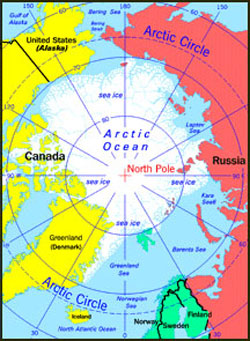
The name given the region around the North Pole. It includes the Arctic Ocean, thousands of islands, and the northern parts of Europe, Asia, and North America, including the Arctic and Subarctic regions of Alaska, Canada, Greenland, Iceland, Scandinavia, Siberia and the Russian Far East. A region of immense beauty far removed from the industrial areas of the world, it is also rich in mineral and other natural resources. Throughout this immense area, economic developers search for oil, gas, and similar marketable natural resources.
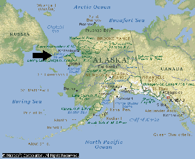
There are two main groups that are referred to as Eskimo: Yupik and Inuit. The Iñupiat are the people of Alaska's Northwest Arctic and North Slope boroughs and the Bering Straits region. Barrow, the northernmost city in the United States, is in the Inupiat region. The Inupiat also live on Siberian Coast, Little Diomede Island and Big Diomede Island.
Greenland's Kalaallit are citizens of Denmark. Another 50,000 Kalaalit Inuit make up almost 90% of the population of Greenland.
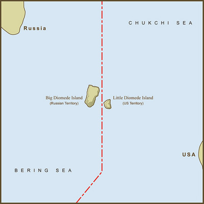
The Diomede Islands are located in the middle of the Bering Strait between mainland Alaska and Siberia, with the Chukchi Sea to the north and the Bering Sea to the south. 9.3 mi (15 km) to the southeast is Fairway Rock, which is generally not considered part of the Diomede Islands. The islands are sometimes called Tomorrow Island (Big Diomede) and Yesterday Isle (Little Diomede) because the time in Big Diomede is 20 hours (approximately a day) ahead of Little Diomede.
http://merrow1.tripod.com/coldwaters/id12.html
In Alaska there are roughly 100,000 iAlaskan natives that make up 16% of the state's population. In addition to the Inuit Inupiat, the Alaskan natives also include the Aleut and Alutiiq peoples who separated from the Inuit approximately 4,000 years ago, and are differentiated in part by their historical contacts with indigenous peoples living in Siberia, and with Native Americans living on the Northwest Coast of the United States Here the term Eskimo is commonly used, because it includes both Yupik and Inupiat, while Inuit is not accepted as a collective term or even specifically used for Inupiat.
The Inuit are a group of culturally similar indigenous peoples inhabiting the Arctic regions of Alaska, Canada, and Greenland. They live throughout most of the Canadian Arctic and subarctic. In Canada, the major indigenous peoples of the Arctic are the roughly 50,000–60,000 Inuit. This population represents the smallest of Canada's three major aboriginal populations. Approximately one-half of the Inuit live in the northeastern territory of Nunavut (where they constitute 85% of the population), less than one-fourth in northern Quebec (i.e., Nunavik), and the remainder in northern Labrador or in Yukon and the Northwest Territories. Many of the Inuit communities are extremely isolated and accessible only by airplane or boat
In Canada and Greenland, the term Eskimo has fallen out of favour, as the Natives prefer the term Inuit. In Canada, the Constitution Act of 1982, sections 25 and 35 recognised the Inuit as a distinctive group of Canadian aboriginals,
In Siberia, according to the Russian Association of Indigenous Peoples of the North, there is a total aboriginal population of 250,000 from more than 40 ethnic groups, including approximately
40,000 Nenets,
35,000 Evenk,
30,000 Khanty, and
20,000 Even
Finally, in the Nordic countries of Norway, Finland, and Sweden live roughly 60,000 Sami although the exact number is considered by some controversial because of their high degree of assimilation within the Nordic populations.
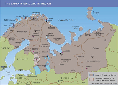
Nenets and Veps living in Russia and Saami living in Finland, Norway, Russia and Sweden are the indigenous peoples of the Barents region. They have ancient traditions for habitation, and traditions for usage of the areas’ resources in a trade context from the times before the national states were established. The indigenous peoples are characterized by own languages, own cultures and own traditions for trade and society.
The Barents Region is a name given, by political ambition to establish international cooperation after the fall of the Soviet Union, to the land along the coast of the Barents Sea, from Nordland in Norway to the Kola Peninsula in Russia and beyond all the way to the Ural Mountains and Novaya Zemlya, and south to the Gulf of Bothnia of the Baltic Sea and the great lakes Ladoga and Onega.
The Arctic Circle includes the islands of Svalbard, an archipelago in the Arctic Ocean north of mainland Europe, about midway between mainland Norway and the North Pole
http://www.pickatrail.com/jupiter/map/svalbard.html
This is a map of Svalbard. The map illustrates the location of Longyearbyen and its proximity to Barentsburg, Spitsbergen, Nordaustlandet, and the Norwegian Sea.
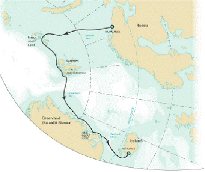
The Arctic Circle includes the islands of Franz Joseph Land, an archipelago located in the far north of Russia. It consists of 191 ice-covered islands with a total area of 16,134 km², located in the northeast Barents Sea region of the Arctic Ocean. They are situated 360 km north from the islands of Novaya Zemlya, 470 km west from Severnaya Zemlya and around 1,000 km south from the geographic North Pole. It has no native inhabitants The islands form the northernmost regions of the European Arctic and are bound by the waters of the open Arctic Ocean to the north, the Barents Sea to the south and by the Kara Sea to the southeast.
http://www.peregrineadventures.com/Media/docs/Arctic-Islands-trip-notes-USD-5686b868-87fe-44e7-ae47-bb4206dd55e1.pdf
In all, there are 6 main islands — Prinz Georg Land (2,741 km²), Wilczek Land (2,054 km²), Graham Bell Island (1,709 km²), Alexandra Land (1,051 km²), Salisbury Island, and Hall Island — and 20 medium-sized islands. The remaining 135 islands are small, accounting for less than half of one percent of the archipelago's area. Terrain on the islands consists of elevated tablelands and low hills
Most of the islands are extensively glaciated — up to 85% of the archipelago's landmass is permanently covered in ice — with an average ice thickness in the region of 180 m. The largest ice mass is found on Graham Bell Island. Glaciers on the islands of the Franz Josef Archipelago are currently in a state of retreat. Large areas of the main islands and their coastal margins remain ice-free however. The sea waters become at their most ice-free in July and August.
Climatic conditions on the islands are not as severe as their latitude would indicate. Winters are severe however, with average temperatures in the region of -25 to -30° C. During the brief summer daily maximums are between 0 and 2°C. Despite the harsh conditions, the islands are ecologically important and are home to important populations of Walrus, Arctic Fox and Polar Bear. Bird species with regionally important colonies include: Little Auk, Black Guillemot, Northern Fulmar, Black-legged Kittiwake and Thick-billed Murre.
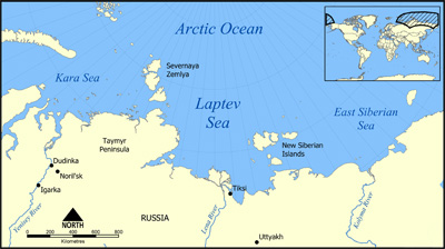
The Arctic Circle includes Severnaya Zemlya an archipelago in the Russian high Arctic at 79°29N 97°19E. Situated off mainland Siberia's Taymyr Peninsula across the Vilkitsky Strait. Severnaya's permafrost prevents it from having any trees.
The Arctic Circle includes Noveya Zemiya Archipelago, used both as an underground test-site for nuclear weapons and for atmospheric testing of nuclear weapons by the former Union of Soviet Socialist Republics — as South Pacific atolls were used by the United States, France and the United Kingdom for their atmospheric testing. Underwater nuclear experiments have continued since the island returned to, or became territory of the Russian Federation. Noveya Zemiya Archipelago presently has close to a hundred indigenous Nenets people that fish and hunt polar bear and seal.
Map of Russian Arctic
http://upload.wikimedia.org/wikipedia/commons/f/f0/Laptev_Sea_map.png
The Arctic Circle also encompasses northern areas of the Scandinavian Peninsula, Kalaallit Nunaat (Greenland)
Map source: greenland.com
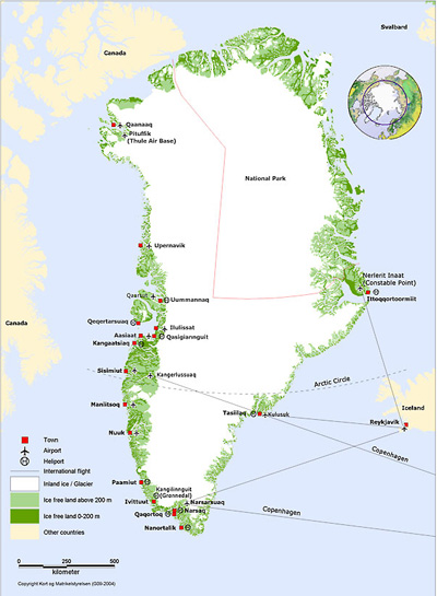
Greenland is the world’s largest island, though four-fifths of the land area lies beneath the second largest ice cap in the world. Ice-free areas are restricted to the coastal fringes, which can be divided into two bio- geographic regions: the low and the high arctic tundra. The high arctic region is located above 75 N latitude at Melville Bay on the West Coast and 70 N at Scoresby Sound, on the East Coast. In a few areas, the ice sheet extends all the way to the coast; the ice-free land of the north is concentrated along the northeast coast. This region is less mountainous than the southern portion, with some rolling hills.
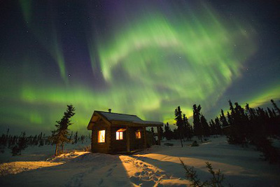
At 80 N latitude, Peary Land is the most northern ice-free landmass in the world. Much of Greenland lies above the Arctic Circle, and like many northern regions is subject to midnight sun (day-round sunlight) in summer as well as polar nights (day-round darkness), which leave the northernmost regions in semi-darkness for four months of winter. The center of frequency for the famed aurora borealis lies just west of Qaanaaq on the northwest coast above Melville Bay . These colored or white flashing lights can be seen when atmospheric molecules are ionized at low temperatures by solar and cosmic radiation.
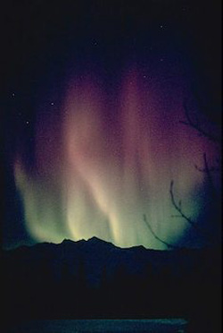
http://www.alaska-in-pictures.com/rainbow-aurora-540-pictures.htm
|